
Tags
Basse-Terre, France, Guadeloupe, hiking, photography, photos, travel
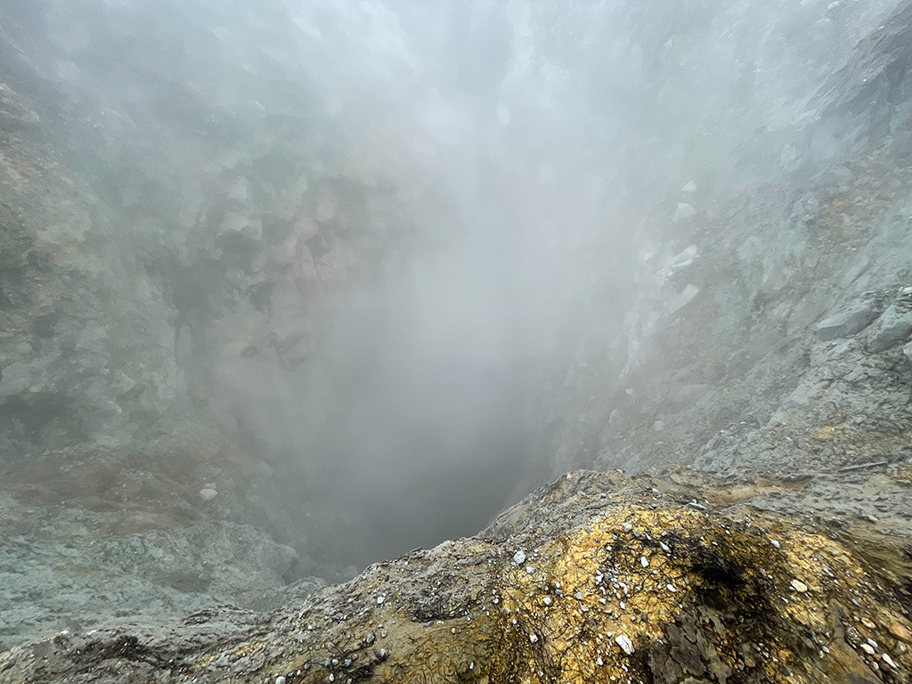
Difficile de venir à Basse-Terre sans faire l’ascension de la Soufrière, le volcan actif qui culmine à 1467m d’altitude, car c’est le 3e site en importance de la Guadeloupe. Nous avons choisi de faire la randonnée (7km et 500m de dénivelé) avec un guide accompagnateur pour pouvoir accéder aux cratères fumants du volcan.
Le départ de la randonnée se fait par le Pas du Roy, un ancien sentier pavé par les militaires au 19e siècle. Donc, pour la première ascension de 200 mètres, tout va bien. Après, on peut « attaquer » la Soufrière par la droite ou la gauche. A gauche, c’est le Chemin des Dames, bien balisé, moins abrupt et plus fréquenté. Notre guide a choisi à droite! Nous irons au sommet par le sentier des Scientifiques, moins balisé, plus abrupt et moins fréquenté. Heureusement, le sentier n’est pas boueux et se parcourt quand même relativement bien. Arrivés près du sommet, nous enfilons les masques respiratoires pour visiter la partie du volcan accessible seulement aux groupes guidés. C’est ici que nous entrons dans le monde fascinant des gouffres et des fumerolles. Le paysage au sommet est assez lunaire, mais couvre une toute petite superficie. Avec la brume, les fumerolles et autres émanations, l’ambiance est magnifique. Après la pause pour manger, nous sommes descendus par le sentier du Chemin des Dames. Ce sentier nous a semblé être une autoroute en comparaison avec le sentier de la montée. Il faut dire qu’environ 200 000 personnes l’empruntent chaque année.
Difficult to come to Basse-Terre without climbing the Soufrière, the active volcano which rises to 1467m above sea level, because it is the 3rd largest site in Guadeloupe. We chose to do the hike (7km and 500m of elevation) with an accompanying guide to be able to access the smoking craters of the volcano.
The start of the hike is via the Pas du Roy, an old path paved by the military in the 19th century. So for the first 200 meter ascent, everything is fine. Afterwards, you can “attack” the Soufrière from the right or the left. On the left is the Chemin des Dames, well signposted, less steep and busier. Our guide chose right! We will go to the summit by the path of the Scientists, less marked, steeper and less frequented. Fortunately, the trail isn’t muddy and the climb goes relatively well. Arriving near the summit, we put on the respiratory masks to visit the part of the volcano accessible only to guided groups. This is where we enter the fascinating world of chasms and fumaroles. The landscape at the top is quite lunar, but covers a very small area. With the mist, fumaroles and other fumes, the atmosphere is magnificent. After the lunch break, we went down the Chemin des Dames trail. This trail felt like a highway to us in comparison to the uphill trail. It must be said that around 200,000 people use it every year.
Le Pas du Roy

Sentier des Scientifiques / Trail of the Scientifics 


Les cratères / The craters


Chemin des Dames


[Auteur/Author: Pierre & Suzanne]

Et pendant ce temps là, d’autres passent des vacances allongés au bord de piscines d’hôtels !!
Merci pour ce partage, bravo pour cette ascension… et récupérez bien !
Merci Marion. Il n’y a rien de mal à se reposer allongés au bord de la piscine…cela fait beaucoup de bien. L’ascension de la Soufrière est vraiment intéressante et pas trop difficile. La végétation (billet un peu plus tard) est absolument fascinante.
la piscine après les balades, oui !! 😀
Wow, that uphill climb looks pretty challenging. Plus, the masks! You guys are real adventurers in my book. Pierre really seems to be enjoying himself.
Thanks Mel. Don’t know if we are real adventurers but we do like going up on mountain sides. This one was pretty steep but quite manageable though the descent was a bit hard on the knees and thighs. We have recently decided to buy walking sticks to give us a boost mostly on the descents. We need to practice on how to use them properly but hopefully they will make a difference. Glad you enjoyed this series.
I agree with Mel and you. The ascent is all about aerobic fitness, the descent is about joint fitness. Clearly you both have both. And the photos were worth the climb. You are right about the landscape looking lunar.
Thanks Jacqui. You are totally right…
I got a pair a few years ago to help with stability but have really no idea how to use them properly. To me they are more of a psychological aid. Will be interested in hearing your experience!
I am a bit concerned about that very fact and actually that is what prevented us from buying them earlier. I will let you know how it is goes once we have used them on hikes a few times…so far we haven’t tried them as we had to order Pierre’s set online as they didn’t have his height in the store. We hope to get them soon…
Passionnant, envoûtant et magnifique. A part l’Etna et le Stromboli (ce second non acitf quand j’y suis allée), je n’ai pas pu aller voir de volcan d’aussi près et je le regrette. Merci beaucoup du partage.
Merci Marie. La Soufrière est effectivement très fascinante car assez actif et recouverte de végétation (plus sur la végétation dans un autre billet).
Nous avons visité l’Etna dans un moment où il n’était pas très actif; le Poas et l’Irazu au Costa Rica (le premier un peu actif et le deuxième éteint); un volcan inactif à Maui et un volcan actif sur Big Island à Hawaii et possiblement quelques autres dont je ne me souviens plus pour l’instant. Toujours une histoire fascinante autour de tous ces volcans.
Vraiment lunaire! Les fotos atmosferiques m’impressonne. J’ai pas de planes d’y visite y pour ca je vous remercie beaucoup les images!
Merci pour votre note. C’est en effet un endroit très intéressant…
That looks like an amazing experience.
Thanks Anabel. It was indeed. A very good & difficult hike but feasible. Our guide was also very good and provided a lot of great information.
Now that looks like a great adventure!
Thanks Eliza. It certainly was and we were very happy to have done it.
Wow I’d love to do this hike, but how difficult was it to hike with the masks?
Thanks for your note. You would probably find this hike not that difficult as you are a good hiker… The portion with the mask isn’t very long as you wear it only when you go across the summit around the various craters where the emanations are toxic. So it isn’t too bad.
Great hike! thanks for sharing. Enjoy! 🙂
Thanks for your note. It was indeed a very interesting though challenging hike. Glad you enjoyed this series.